import warnings; warnings.filterwarnings("ignore")The Solar Dynamics Observatory (SDO, Pesnell et al. 2012) / Helioseismic and Magnetic Imager (HMI, Schou et al. 2012) have produced a wealth of data for the Sun, particularly the magnetic field on the solar surface (photosphere). The Space-Weather HMI Active Region Patches (SHARPs, Bobra et al. 2014) are a set of data products derived from the HMI data, which have been used extensively in solar physics and space weather research. The information for the SHARP data is available on this JSOC page.
This post focuses on how to download the SHARP CEA data from the JSOC.
NOAA AR to HARP Matching
A record of the SHARP data series is identified by two prime keywords: HARPNUM (HARP number) and T_REC (observation time). Since HARP is identified independently from the National Oceanic and Atmospheric Administration (NOAA), the HARP number is different from NOAA active region (AR) number. Even one HARP can correspond to zero, one, or more NOAA ARs. There is a file for mapping between HARP numbers and NOAA AR numbers here.
Also, the SHARP keywords include those for NOAA AR numbers, which start with NOAA_.
sharp.keywords[sharp.keywords.index.str.startswith('NOAA_')]| type | recscope | defval | units | note | linkinfo | is_time | is_integer | is_real | is_numeric | |
|---|---|---|---|---|---|---|---|---|---|---|
| name | ||||||||||
| NOAA_AR | int | variable | -2147483648 | none | NOAA AR number that best matches this HARP | None | False | True | False | True |
| NOAA_NUM | int | variable | -2147483648 | none | Number of NOAA ARs that match this HARP (0 allowed) | None | False | True | False | True |
| NOAA_ARS | string | variable | none | Comma-separated list of NOAA ARs matching this HARP | None | False | False | False | False |
As an example, let’s find the HARP number corresponding to the NOAA AR number 12673 which produced the largest solar flare in solar cycle 24.
To do this, we need to query keywords HARPNUM and NOAA_AR using the drms.Client.query method. The key argument specifies which keywords to query. We need to use two primary keys: the HARP number (blank in this case) and the time range (2017-09-04T00:00:00 in this case).
results = c.query('hmi.sharp_720s[][2017-09-04T00:00:00]', key=['HARPNUM', 'NOAA_AR', 'NOAA_ARS', 'NOAA_NUM'])results| HARPNUM | NOAA_AR | NOAA_ARS | NOAA_NUM | |
|---|---|---|---|---|
| 0 | 7115 | 12673 | 12673 | 1 |
| 1 | 7117 | 12674 | 12674,12679 | 2 |
| 2 | 7118 | 0 | MISSING | 0 |
| 3 | 7120 | 12675 | 12675 | 1 |
| 4 | 7121 | 0 | MISSING | 0 |
| 5 | 7122 | 12677 | 12677 | 1 |
| 6 | 7123 | 12675 | 12675,12676 | 2 |
As you can see, the HARP number for the NOAA AR 12673 is 7115.
There are summary images for HARP data here. The following image is the summary image for the HARPs on 2017-09-04T00:00:00.
from IPython.display import Image

Image('http://jsoc.stanford.edu/doc/data/hmi/harp/harp_definitive/2017/09/04/harp.2017.09.04_00:00:00_TAI.png')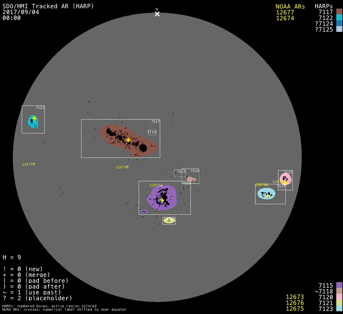
At this time, the AR 12673 (HARP 7115) is located near the center of the solar disk, with a slight southward shift.
SHARP CEA Data
Let’s now download the SHARP CEA data for the HARP 7115 (NOAA AR 12673) on 2017-09-04T00:00:00.
There are basically two ways to download data from the JSOC:
- Download merged FITS files (export), which requires an email address registered here.
- Download segments (data) and keywords (metadata) separately and merge them as FITS files if needed.
# Construct query
query = 'hmi.sharp_cea_720s[7115][2017-09-04T00:00:00]'
1. Download merged FITS files
from pathlib import Path
sharp_cea_path = Path('./data/export/sharp_cea')
sharp_cea_path.mkdir(parents=True, exist_ok=True)
email = '' # A registered email address
c = drms.Client(email=email)
r = c.export(query, protocol='fits')
r.wait()
if r.status == 0:
r.download(sharp_cea_path)Since this is the SHARP CEA data, there are 11 files (segments) in total.
sharp_cea_list = sorted(sharp_cea_path.glob('*.fits'))
print(len(sharp_cea_list))
for file in sharp_cea_list:
    print(file.name)
11
hmi.sharp_cea_720s.7115.20170904_000000_TAI.bitmap.fits
hmi.sharp_cea_720s.7115.20170904_000000_TAI.Bp.fits
hmi.sharp_cea_720s.7115.20170904_000000_TAI.Bp_err.fits
hmi.sharp_cea_720s.7115.20170904_000000_TAI.Br.fits
hmi.sharp_cea_720s.7115.20170904_000000_TAI.Br_err.fits
hmi.sharp_cea_720s.7115.20170904_000000_TAI.Bt.fits
hmi.sharp_cea_720s.7115.20170904_000000_TAI.Bt_err.fits
hmi.sharp_cea_720s.7115.20170904_000000_TAI.conf_disambig.fits
hmi.sharp_cea_720s.7115.20170904_000000_TAI.continuum.fits
hmi.sharp_cea_720s.7115.20170904_000000_TAI.Dopplergram.fits
hmi.sharp_cea_720s.7115.20170904_000000_TAI.magnetogram.fitsUsing sunpy.map.Map, we can easily read the SHARP CEA data and visualize it. Let’s see the Br component of the magnetic field.
from sunpy.map import Map

sharp_cea_br = Map(sharp_cea_path / 'hmi.sharp_cea_720s.7115.20170904_000000_TAI.Br.fits')
sharp_cea_br.peek()
The below shows the FITS header of this file.
sharp_cea_br.fits_headerSIMPLE = T / file does conform to FITS standard
BITPIX = 32 / data type of original image
NAXIS = 2 / dimension of original image
NAXIS1 = 688 / length of original image axis
NAXIS2 = 448 / length of original image axis
BLANK = -2147483648
BZERO = 0.0
BSCALE = 0.01
CHECKSUM= 'ZoJAflG8ZlGAflG5' / HDU checksum updated 2025-08-01T11:36:33
DATASUM = '2018488944' / data unit checksum updated 2017-10-09T03:05:15
DATE = '2017-10-09T03:04:53.000' / [ISO] HDU creation date
DATE_S = '2017-09-08T17:19:08.000' / [ISO] Date_time of generating Stokes data
DATE_B = '2017-09-10T08:49:19.000' / [ISO] Date_time of generating Bharp data
DATE-OBS= '2017-09-03T23:58:42.200' / [ISO] Observation date {DATE__OBS}
T_OBS = '2017.09.04_00:00:04.203_TAI' / [TAI] nominal time
T_REC = '2017.09.04_00:00:00.000_TAI' / [TAI] Slot time
TRECEPOC= '1993.01.01_00:00:00.000_TAI' / [TAI] Time of origin {T_REC_epoch}
TRECSTEP= 720.0 / [seconds] ts_eq step {T_REC_step}
TRECUNIT= 'secs ' / ts_eq unit {T_REC_unit}
CADENCE = 720.0 / [seconds] repetition interval
USFLUX = 2.33095666E+22 / [Maxwell] Total unsigned flux
MEANGAM = 60.9712143 / [Degrees] Mean inclination angle, gamma
MEANGBT = 108.533112 / [Gauss/Mm] Mean value of the total field gradie
MEANGBZ = 122.083214 / [Gauss/Mm] Mean value of the vertical field gra
MEANGBH = 81.9712906 / [Gauss/Mm] Mean value of the horizontal field g
MEANJZD = -0.176174253 / [mA/(m^2)] Mean vertical current density
TOTUSJZ = 56044520700000.0 / [Amperes] Total unsigned vertical current
MEANALP = -0.0666425973 / [1/Mm] Mean twist parameter, alpha
MEANJZH = -0.0351469964 / [(G^2)/m] Mean current helicity
TOTUSJH = 3211.80591 / [(G^2)/m] Total unsigned current helicity
ABSNJZH = 1280.44019 / [(G^2)/m] Absolute value of the net current hel
SAVNCPP = 53733652200000.0 / [Amperes] Sum of the Absolute Value of the Net
MEANPOT = 17168.6914 / [Ergs per cubic centimeter] Mean photospheric e
TOTPOT = 8.30700913E+23 / [Ergs per cubic centimeter] Total photospheric
MEANSHR = 51.6004753 / [Degrees] Mean shear angle for B_total
SHRGT45 = 57.4177246 / [Percentage of Total] Area with shear angle gre
R_VALUE = 4.91179323 / [Maxwell] Unsigned Flux R (Schrijver, 2007)
GWILL = / [Mm] (MISSING) GWILL (Mason & Hoeksema, 2010)
CTYPE1 = 'CRLN-CEA' / CRLN
CTYPE2 = 'CRLT-CEA' / CRLT
CRPIX1 = 344.5 / [pixel] X coordinate of patch center with respe
CRPIX2 = 224.5 / [pixel] Y coordinate of patch center with respe
CRVAL1 = 118.228928 / [degree] Longitude at center of patch
CRVAL2 = -9.24354935 / [degree] Latitude at center of patch
CDELT1 = 0.0299999993 / [degree] Map scale in X direction
CDELT2 = 0.0299999993 / [degree] Map scale in Y direction
CUNIT1 = 'degree ' / Degree
CUNIT2 = 'degree ' / Degree
IMCRPIX1= 2040.19434 / [pixel] Location of the Sun center in CCD x dir
IMCRPIX2= 2050.66919 / [pixel] Location of the Sun center in CCD y dir
IMCRVAL1= 0.0 / [arcsec] x origin
IMCRVAL2= 0.0 / [arcsec] y origin
CROTA2 = 0.0 / [deg] CROTA2: INST_ROT + SAT_ROT
CRDER1 = 0.0 / [arcsec] CRDER1: estimate of random error in co
CRDER2 = 0.0 / [arcsec] CRDER2: estimate of random error in co
CSYSER1 = / [arcsec] (MISSING) CSYSER1: estimate of systema
CSYSER2 = / [arcsec] (MISSING) CSYSER2: estimate of systema
WCSNAME = 'Carrington Heliographic' / WCS system name
DSUN_OBS= 150858023996.63818 / [meters] Distance from SDO to Sun center.
DSUN_REF= 149597870691.0 / [meters] Astronomical Unit
RSUN_REF= 696000000.0 / [m] Reference radius of the Sun: 696,000,000.0
CRLN_OBS= 115.300667 / [deg] Carrington longitude of the observer
CRLT_OBS= 7.24144268 / [deg] Carrington latitude of the observer
CAR_ROT = 2194 / Carrington rotation number of CRLN_OBS
OBS_VR = 2555.889497463884 / [m/s] velocity of the observer in radial direct
OBS_VW = 28877.653628739867 / [m/s] velocity of the observer solar
OBS_VN = 611.9685861024672 / [m/s] velocity of the observer solar
RSUN_OBS= 951.628662109375 / [arcsec] angular radius of Sun. Corresponds to
TELESCOP= 'SDO/HMI ' / Telescope
INSTRUME= 'HMI_COMBINED' / For HMI: HMI_SIDE1, HMI_FRONT2, or HMI_COMBINED
WAVELNTH= 6173.0 / [angstrom] Wavelength
CAMERA = 3 / Camera
QUALITY = 0 / SHARP Quality index
QUAL_S = 0 / Level 1p Quality word
QUALLEV1= 0 / Level 1 quality
BUNIT = 'Mx/cm^2 ' / Physical Units {BUNIT_006}
ORIGIN = 'SDO/JSOC-SDP' / Origin
CONTENT = 'HMI observable' / Content
BLD_VERS= 'V9R1X ' / JSOC
CALVER64= 204818 / Calibration Version
CODEVER7= '$Id: sharp.c,v 1.38 2015/03/18 00:28:26 xudong Exp $ $Id' / CVS Versi
HFLID = 1022 / HMI_SEQ_ID_FRAMELIST
HCFTID = 11 / HMI_SEQ_ID_FOCUS
QLOOK = 0 / QLOOK: 0=final data, 1=quick
HARPNUM = 7115 / HARP ID
MASK = 32 / Lower threshold for membership in this patch
ARM_QUAL= 0 / Quality of the mask (bitfield)
ARM_NCLN= 0 / Number of limb pixels reset to quiet (annulus w
H_MERGE = 0 / 1 if this HARP merged with an existing region a
H_FAINT = 0 / 1 if this HARP had faint contrast at this time
ARM_MODL= '/builtin/hmi.M_Ic_noLimbDark_720s.production' / ARmask parameter: Cla
ARM_EDGE= 2.5 / ARmask parameter: Width of annulus at limb to p
ARM_BETA= '0.3 ' / ARmask parameter: Mask spatial smoothness
LATDTMIN= -15.9709997 / [degree] Minimum latitude for disk transit
LONDTMIN= -7.3888998 / [degree] Minimum longitude for disk transit
LATDTMAX= -2.51609993 / [degree] Maximum latitude for disk transit
LONDTMAX= 13.2454004 / [degree] Maximum longitude for disk transit
OMEGA_DT= 13.5587997 / [degree/day] Rotation rate over disk transit
NPIX = 104669 / Number of pixels within the patch
SIZE = 9358.12109 / [mH] Projected area of patch on image in micro
AREA = 4898.90918 / [mH] De
NACR = 20091 / Number of active pixels in patch
SIZE_ACR= 1796.27209 / [mH] Projected area of active pixels on image i
AREA_ACR= 938.419678 / [mH] De
MTOT = 14614653.0 / [weber] Sum of absolute LoS flux within the ide
MNET = 2694764.75 / [weber] Net LoS flux within the identified regi
MPOS_TOT= 8654709.0 / [weber] Absolute value of total positive LoS fl
MNEG_TOT= 5959944.0 / [weber] Absolute value of total negative LoS fl
MMEAN = 25.7455864 / [gauss] Mean of LoS flux density
MSTDEV = 317.047974 / [gauss] Standard deviation of LoS flux density
MSKEW = 1.03884447 / Skewness of LoS flux density
MKURT = 8.83417225 / Kurtosis of LoS flux density
LAT_MIN = -15.703517 / [degree] Minimum Stonyhurst latitude of pixels
LON_MIN = -6.76720762 / [degree] Minimum Stonyhurst longitude of pixels
LAT_MAX = -3.89583516 / [degree] Maximum Stonyhurst latitude of pixels
LON_MAX = 7.71703625 / [degree] Maximum Stonyhurst longitude of pixels
LAT_FWT = -9.06213856 / [degree] Stonyhurst latitude of flux
LON_FWT = 2.20005369 / [degree] Stonyhurst longitude of flux
LATFWTPO= -9.32380581 / [degree] Stonyhurst latitude of flux {LAT_FWTPO
LONFWTPO= 2.86910152 / [degree] Stonyhurst longitude of flux {LON_FWTP
LATFWTNE= -8.63728142 / [degree] Stonyhurst latitude of flux {LAT_FWTNE
LONFWTNE= 1.11375129 / [degree] Stonyhurst longitude of flux {LON_FWTN
T_FRST = '2017.08.27_10:00:00.000_TAI' / [TAI] First T_REC stored for HARP (inc
T_FRST1 = '2017.08.28_08:12:00.000_TAI' / [TAI] T_REC of initial HARP detection
T_LAST1 = '2017.09.10_11:12:00.000_TAI' / [TAI] T_REC of final HARP detection
T_LAST = '2017.09.11_03:48:00.000_TAI' / [TAI] Last T_REC stored for HARP (incl
N_PATCH = 1676 / Image slots spanned by HARP (includes pad)
N_PATCH1= 1491 / Image slots spanned by HARP (excludes pad)
N_PATCHM= 85 / Missing images/slots in unpadded HARP interval
NOAA_AR = 12673 / NOAA AR number that best matches this HARP
NOAA_NUM= 1 / Number of NOAA ARs that match this HARP (0 allo
NOAA_ARS= '12673 ' / Comma
INVCODEV= 'vfisvcombine FD10 2013 Apr. 30; uses time-dependent HMI filter &'
CONTINUE 'phase maps&'
CONTINUE '' / Version of VFISV code
INVDOCU = / (MISSING) Document for VFISV code
INVITERA= 200 / Number of iterations of VFISV
INVSTLGT= 'No ' / Flag for stray light. No means that the stray l
INVFLPRF= '' / Flag/Comment on filter
INVPHMAP= '121048472' / Flag/Comment on phase map
USFLUXL = 2.04952041124192E+22 / [Maxwell] Total unsigned flux {INVVLAVE}
MEANGBL = 39.11368179321289 / [Gauss/Mm] Mean value of the line {INVBLAVE}
INVBBAVE= 121.28715632506182 / [gauss] avarage of inverted field strength over
CMASKL = 111256 / [number] Number of pixels that contributed to t
INVNCNVG= 11184843 / Numer of pixels at which ME VFISV converged
AMBCODEV= 'disambig_v3 2013 Dec 06' / Version of Disambig code
AMBDOCU = / (MISSING) Document for Disambig code
AMBGMTRY= 2 / Flag determining whether to use planar or spher
AMBPATCH= 0 / Flag determining whether disambiguation is done
AMBWEAK = 2 / Flag determining method for disambiguating weak
AMBNEROD= 1 / [pixels] Number of pixels by which to erode map
AMBNGROW= 5 / [pixels] Number of pixels by which to grow erod
AMBNPAD = 200 / [pixels] Padding to use in potential field calc
AMBNAP = 10 / [pixels] Width of apodizing window in potential
AMBNTX = 30 / Number of tiles to use in x
AMBNTY = 30 / Number of tiles to use in y
AMBBTHR0= 200.0 / [G] Transverse field strength threshold at disk
AMBBTHR1= 400.0 / [G] Transverse field strength threshold at limb
AMBSEED = 4 / Input random number seed
AMBNEQ = 100 / Number of reconfigurations attempted at each te
AMBLMBDA= 1.0 / Weighting factor between divergence and vertica
AMBTFCT0= 2.0 / Input factor to scale initial temperature
AMBTFCTR= 0.9800000190734863 / Input factor to reduce temperature
DATAVALS= 308224 / Data values {DATAVALS_006}
MISSVALS= 0 / Missing values {MISSVALS_006}
DATAMIN = -2184.78003 / Minimum value {DATAMIN_006}
DATAMAX = 2745.38989 / Maximum value {DATAMAX_006}
DATAMEDN= -3.6447506 / Median value {DATAMEDN_006}
DATAMEAN= 4.10086536 / Mean value from pixels within 99% of solar radi
DATARMS = 254.120453 / RMS {DATARMS_006}
ERRGAM = 0.0170187168 / [Degrees] Error in Mean inclination angle, gamm
ERRTAI = 20.9685936 / [(G^2)/m] Absolute value of the net current hel
ERRBH = 0.166585341 / [Gauss/Mm] Error in Mean value of the horizonta
ERRMPOT = 10.9116526 / [Ergs per cubic centimeter] Error in Mean photo
ERRBT = 0.140896067 / [Gauss/Mm] Error in Mean value of the total fie
ERRTUI = 20.9685936 / [(G^2)/m] Total unsigned current helicity
ERRBZ = 0.103350542 / [Gauss/Mm] Error in Mean value of the vertical
CMASK = 36433.0 / [number] Number of pixels that contributed to t
ERRJZ = 0.0505617075 / [mA/(m^2)] Error in Mean vertical current densi
ERRVF = 7.0435523E+18 / [Maxwell] Error in Total unsigned flux
ERRALP = 0.0010908118 / [1/Mm] Error in Mean twist parameter, alpha
ERRMIH = 0.000575570099 / [(G^2)/m] Mean current helicity
ERRMSHA = 0.000446339604 / [Degrees] Error in Mean shear angle for B_total
ERRUSI = 244641006000.0 / [Amperes] Error in Total unsigned vertical curr
DOFFSET = 50 / [Gauss] Constant value added to the noise mask
ERRTPOT = 5.27956351E+20 / [Ergs per cubic centimeter] Error in Total phot
ERRJHT = 985371771000.0 / [Amperes] Sum of the Absolute Value of the Net
RECNUM = 6009474 / Recnum
DRMS_ID = 'hmi.sharp_cea_720s:6009474:Br' / DRMS ID
PRIMARYK= 'HARPNUM, T_REC' / DRMS primary key
LICENSE = 'LICENSE ' / CC0 1.0
HEADSUM = 'ZAjnaAhkTAhkZAhk' / Keyword checksum
LONGSTRN= 'OGIP 1.0' / The HEASARC Long String Convention may be used.
WAVEUNIT= 'angstrom'
COMMENT FITS (Flexible Image Transport System) format is defined in 'Astronomy
COMMENT and Astrophysics', volume 376, page 359; bibcode: 2001A&A...376..359H
COMMENT This FITS file may contain long string keyword values that are
COMMENT continued over multiple keywords. The HEASARC convention uses the &
COMMENT character at the end of each substring which is then continued
COMMENT on the next keyword which has the name CONTINUE.
HISTORY 2. Download segments and keywords separately
c = drms.Client() # No email address neededAll keywords associated with the query can be obtained using drms.JsocInfoConstants.all.
keywords = c.query(query, key=drms.JsocInfoConstants.all)
keywords| DATE | DATE_S | DATE_B | DATE__OBS | DATE-OBS | T_OBS | T_REC | T_REC_epoch | T_REC_step | T_REC_unit | ... | CMASK | ERRJZ | ERRVF | ERRALP | ERRMIH | ERRMSHA | ERRUSI | DOFFSET | ERRTPOT | ERRJHT | |
|---|---|---|---|---|---|---|---|---|---|---|---|---|---|---|---|---|---|---|---|---|---|
| 0 | 2017-10-09T03:04:53Z | 2017-09-08T17:19:08Z | 2017-09-10T08:49:19Z | 2017-09-03T23:58:42.20Z | 2017-09-03T23:58:42.20Z | 2017.09.04_00:00:04_TAI | 2017.09.04_00:00:00_TAI | 1993.01.01_00:00:00_TAI | 720.0 | secs | ... | 36433.0 | 0.050562 | 7.043552e+18 | 0.001091 | 0.000576 | 0.0 | 2.446410e+11 | 50 | 5.279564e+20 | 9.853718e+11 |
1 rows × 261 columns
We can get a list of names of segments using drms.Client.info and then query the keywords and segments using drms.Client.query.
sharp_cea = c.info('hmi.sharp_cea_720s')
sharp_cea_segments = sorted(sharp_cea.segments.index)
print(sharp_cea_segments)
['Bp', 'Bp_err', 'Br', 'Br_err', 'Bt', 'Bt_err', 'Dopplergram', 'bitmap', 'conf_disambig', 'continuum', 'magnetogram']keywords, segments = c.query(query, key=drms.JsocInfoConstants.all, seg=sharp_cea_segments)keywords| DATE | DATE_S | DATE_B | DATE__OBS | DATE-OBS | T_OBS | T_REC | T_REC_epoch | T_REC_step | T_REC_unit | ... | CMASK | ERRJZ | ERRVF | ERRALP | ERRMIH | ERRMSHA | ERRUSI | DOFFSET | ERRTPOT | ERRJHT | |
|---|---|---|---|---|---|---|---|---|---|---|---|---|---|---|---|---|---|---|---|---|---|
| 0 | 2017-10-09T03:04:53Z | 2017-09-08T17:19:08Z | 2017-09-10T08:49:19Z | 2017-09-03T23:58:42.20Z | 2017-09-03T23:58:42.20Z | 2017.09.04_00:00:04_TAI | 2017.09.04_00:00:00_TAI | 1993.01.01_00:00:00_TAI | 720.0 | secs | ... | 36433.0 | 0.050562 | 7.043552e+18 | 0.001091 | 0.000576 | 0.0 | 2.446410e+11 | 50 | 5.279564e+20 | 9.853718e+11 |
1 rows × 261 columns
segments| Bp | Bp_err | Br | Br_err | Bt | Bt_err | Dopplergram | bitmap | conf_disambig | continuum | magnetogram | |
|---|---|---|---|---|---|---|---|---|---|---|---|
| 0 | /SUM98/D978177825/S00000/Bp.fits | /SUM98/D978177825/S00000/Bp_err.fits | /SUM98/D978177825/S00000/Br.fits | /SUM98/D978177825/S00000/Br_err.fits | /SUM98/D978177825/S00000/Bt.fits | /SUM98/D978177825/S00000/Bt_err.fits | /SUM98/D978177825/S00000/Dopplergram.fits | /SUM98/D978177825/S00000/bitmap.fits | /SUM98/D978177825/S00000/conf_disambig.fits | /SUM98/D978177825/S00000/continuum.fits | /SUM98/D978177825/S00000/magnetogram.fits |
Using the url information for each segment, we can download each file.
t_rec = keywords['T_REC'].item()
t_rec'2017.09.04_00:00:00_TAI'segment = segments['Br'].item()
print(segment)/SUM98/D978177825/S00000/Br.fitsurl = 'http://jsoc.stanford.edu' + segment
url'http://jsoc.stanford.edu/SUM98/D978177825/S00000/Br.fits'from urllib.request import urlretrieve
urlretrieve(url, 'Br.fits');from astropy.io import fits
hdul = fits.open('Br.fits')
hdul.info()Filename: Br.fits
No. Name Ver Type Cards Dimensions Format
0 PRIMARY 1 PrimaryHDU 6 ()
1 COMPRESSED_IMAGE 1 CompImageHDU 10 (688, 448) int32 hdul[1].headerSIMPLE = T / file does conform to FITS standard
BITPIX = 32 / data type of original image
NAXIS = 2 / dimension of original image
NAXIS1 = 688 / length of original image axis
NAXIS2 = 448 / length of original image axis
BLANK = -2147483648
BZERO = 0.
BSCALE = 0.01
CHECKSUM= 'lBDPo99OlACOl99O' / HDU checksum updated 2017-10-09T03:05:15
DATASUM = '2018488944' / data unit checksum updated 2017-10-09T03:05:15 As you can see, the header contains only basic information. However, the data is exactly the same as the one downloaded using the drms.Client.export method.
import numpy as np
np.allclose(hdul[1].data, sharp_cea_br.data)Truehdul.close()We can construct a header from the keywords. Note that there is no DATE-OBS in the keywords, instead DATE__OBS exists. The following note comes from the “4.2.4 JSOC Image Timing Details” section of the Guide to SDO Data Analysis.
TECHNICAL NOTE: The JSOC keyword naming convention does not allow for hyphens, and consequently the DATE-OBS keyword is represented as DATE__OBS (with two underscores) within the JSOC. However, upon export to FITS files, this keyword gets converted to DATE-OBS so as to be compliant with the FITS standard. Additionally, note that the keyword DATE_OBS (with one underscore) that was more common during the SOHO era is not used by the JSOC.
I refer to this code for the following code.
from sunpy.util import MetaDict
from sunpy.io._fits import header_to_fits

header = keywords.iloc[0].to_dict()
header['DATE_OBS'] = header['DATE__OBS']
header = header_to_fits(MetaDict(header))

with fits.open('Br.fits', 'update') as f:
    hdr = f[1].header
    for k, v in header.items():
        if pd.isna(v):
            continue
        hdr[k] = v
    f.verify('silentfix')
sharp_cea_br_sep = Map('Br.fits')
sharp_cea_br_sep.peek()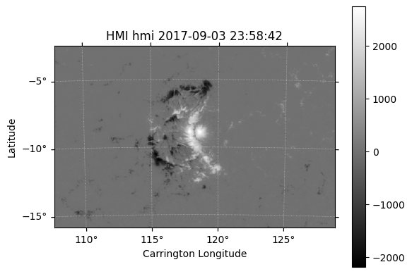
sharp_cea_br_sep.fits_headerSIMPLE = T / file does conform to FITS standard
BITPIX = 32 / data type of original image
NAXIS = 2 / dimension of original image
NAXIS1 = 688 / length of original image axis
NAXIS2 = 448 / length of original image axis
BLANK = -2147483648
BZERO = 0.0
BSCALE = 0.01
CHECKSUM= 'U0UHV0S9U0SEU0S9' / HDU checksum updated 2025-08-01T22:17:03
DATASUM = '2018488944' / data unit checksum updated 2025-08-01T22:17:03
DATE = '2017-10-09T03:04:53Z'
DATE_S = '2017-09-08T17:19:08Z'
DATE_B = '2017-09-10T08:49:19Z'
DATE-OBS= '2017-09-03T23:58:42.20Z'
T_OBS = '2017.09.04_00:00:04_TAI'
T_REC = '2017.09.04_00:00:00_TAI'
CADENCE = 720.0
USFLUX = 2.330957E+22
MEANGAM = 60.971
MEANGBT = 108.533
MEANGBZ = 122.083
MEANGBH = 81.971
MEANJZD = -0.17617425
TOTUSJZ = 56044520000000.0
MEANALP = -0.0666426
MEANJZH = -0.035147
TOTUSJH = 3211.806
ABSNJZH = 1280.44
SAVNCPP = 53733650000000.0
MEANPOT = 17168.69
TOTPOT = 8.307009E+23
MEANSHR = 51.6
SHRGT45 = 57.418
R_VALUE = 4.912
CTYPE1 = 'CRLN-CEA'
CTYPE2 = 'CRLT-CEA'
CRPIX1 = 344.5
CRPIX2 = 224.5
CRVAL1 = 118.228928
CRVAL2 = -9.243549
CDELT1 = 0.03
CDELT2 = 0.03
CUNIT1 = 'degree '
CUNIT2 = 'degree '
IMCRPIX1= 2040.194336
IMCRPIX2= 2050.669189
IMCRVAL1= 0.0
IMCRVAL2= 0.0
CROTA2 = 0.0
WCSNAME = 'Carrington Heliographic'
DSUN_OBS= 150858023996.64
DSUN_REF= 149597870691
RSUN_REF= 696000000
CRLN_OBS= 115.300667
CRLT_OBS= 7.241443
CAR_ROT = 2194
OBS_VR = 2555.889497
OBS_VW = 28877.653629
OBS_VN = 611.968586
RSUN_OBS= 951.628662
TELESCOP= 'SDO/HMI '
INSTRUME= 'HMI_COMBINED'
WAVELNTH= 6173.0
CAMERA = 3
QUALITY = 0
QUAL_S = 0
QUALLEV1= 0
ORIGIN = 'SDO/JSOC-SDP'
CONTENT = 'HMI observable'
BLD_VERS= 'V9R1X '
CALVER64= 204818
HFLID = 1022
HCFTID = 11
QLOOK = 0
HARPNUM = 7115
MASK = 32
ARM_QUAL= 0
ARM_NCLN= 0
H_MERGE = 0
H_FAINT = 0
ARM_MODL= '/builtin/hmi.M_Ic_noLimbDark_720s.production'
ARM_EDGE= 2.5
ARM_BETA= '0.3 '
LATDTMIN= -15.971
LONDTMIN= -7.3889
LATDTMAX= -2.5161
LONDTMAX= 13.2454
OMEGA_DT= 13.5588
NPIX = 104669
SIZE = 9358.121094
AREA = 4898.90918
NACR = 20091
SIZE_ACR= 1796.272095
AREA_ACR= 938.419678
MTOT = 14614653.0
MNET = 2694764.75
MPOS_TOT= 8654709.0
MNEG_TOT= 5959944.0
MMEAN = 25.745586
MSTDEV = 317.047974
MSKEW = 1.038844
MKURT = 8.834172
LAT_MIN = -15.703517
LON_MIN = -6.767208
LAT_MAX = -3.895835
LON_MAX = 7.717036
LAT_FWT = -9.062139
LON_FWT = 2.200054
T_FRST = '2017.08.27_10:00:00_TAI'
T_FRST1 = '2017.08.28_08:12:00_TAI'
T_LAST1 = '2017.09.10_11:12:00_TAI'
T_LAST = '2017.09.11_03:48:00_TAI'
N_PATCH = 1676
N_PATCH1= 1491
N_PATCHM= 85
NOAA_AR = 12673
NOAA_NUM= 1
NOAA_ARS= '12673 '
INVCODEV= 'vfisvcombine FD10 2013 Apr. 30; uses time-dependent HMI filter &'
CONTINUE 'phase maps'
INVDOCU = 'MISSING '
INVITERA= 200
INVSTLGT= 'No '
INVFLPRF= ''
INVPHMAP= '121048472'
INVVLAVE= 2.04952E+22
USFLUXL = 2.04952E+22
INVBLAVE= 39.114
MEANGBL = 39.114
INVBBAVE= 121.2872
INVNPRCS= 111256
CMASKL = 111256
INVNCNVG= 11184843
AMBCODEV= 'disambig_v3 2013 Dec 06'
AMBDOCU = 'MISSING '
AMBGMTRY= 2
AMBPATCH= 0
AMBWEAK = 2
AMBNEROD= 1
AMBNGROW= 5
AMBNPAD = 200
AMBNAP = 10
AMBNTX = 30
AMBNTY = 30
AMBBTHR0= 200.0
AMBBTHR1= 400.0
AMBSEED = 4
AMBNEQ = 100
AMBLMBDA= 1.0
AMBTFCT0= 2.0
AMBTFCTR= 0.98
ERRGAM = 0.017
ERRTAI = 20.969
ERRBH = 0.167
ERRMPOT = 10.91165
ERRBT = 0.141
ERRTUI = 20.969
ERRBZ = 0.103
CMASK = 36433.0
ERRJZ = 0.05056171
ERRVF = 7.043552E+18
ERRALP = 0.00109081
ERRMIH = 0.00057557
ERRMSHA = 0.0
ERRUSI = 244641000000.0
DOFFSET = 50
ERRTPOT = 5.279564E+20
ERRJHT = 985371800000.0
DATE_OBS= '2017-09-03T23:58:42.20Z'
HISTORY
COMMENT The header is not exactly the same as the one downloaded using the drms.Client.export method, but it is basically the same as you can see.